Orgues basaltiques
Randonnée depuis Mahina. #Randonnée
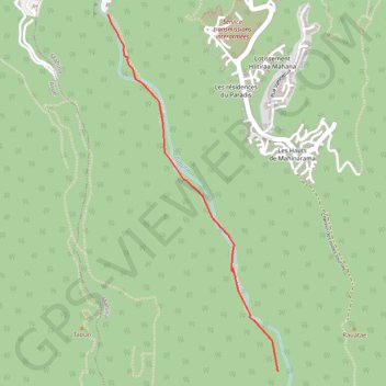
- Distance: 3.1 Km
- Elevation gain: 211 m
- Maximum elevation: 216 m
- Elevation loss: 54 m
- Minimum elevation: 58 m
- Moving time: 1 h 50 m
- Moving speed: 1.7 Km/h
- Maximum speed: 9.8 Km/h
- Total time: 2 h 17 m
- Global speed: 1.4 Km/h
- Date: 05/10/2014
Interactive map
GPS track profile
About this GPS track
Name: Orgues basaltiques GPS track, route, trail
Coordinates: -17.55720 -149.48862 -17.53382 -149.47698
Other GPS tracks
Click on a GPS track to view route, its statistics and profile.
02-JAN-16 02:37:35 PM
France > Polynésie française > Îles du Vent > Arue
Distance: 13.8 Km • Elevation gain: 871 m • Maximum elevation: 945 m