BELLEVUE
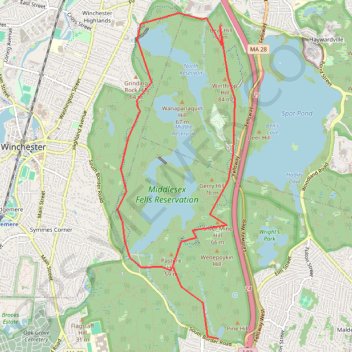
Bike Loop Bellevue
- Distance: 11.2 Km
- Elevation gain: 126 m
- Maximum elevation: 88 m
- Elevation loss: 126 m
- Minimum elevation: 29 m
Interactive map
GPS track profile
About this GPS track
Name: BELLEVUE GPS track, route, trail
Start: Quarry Road, Medford, Middlesex County, Massachusetts, 02155, United States (42.43095 -71.10763)
Coordinates: 42.43095 -71.12285 42.46711 -71.10512
Other GPS tracks
Click on a GPS track to view route, its statistics and profile.
Exploring
United States > Massachusetts > Suffolk County > Boston
Distance: 66.2 Km • Elevation gain: 604 m • Maximum elevation: 137 m