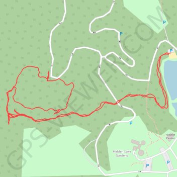
Hidden Lake Gardens Kettle Hole Trail
- Distance: 2.9 Km
- Elevation gain: 32 m
- Maximum elevation: 322 m
- Elevation loss: 31 m
- Minimum elevation: 297 m
- Moving time: 51 m 25 s
- Moving speed: 3.4 Km/h
- Maximum speed: 12.3 Km/h
- Total time: 1 h 13 m
- Global speed: 2.4 Km/h
- Date: 07/04/2024
Interactive map
GPS track profile
About this GPS track
Name: Hidden Lake Gardens Kettle Hole Trail GPS track, route, trail
Coordinates: 42.03021 -84.11733 42.03241 -84.11055
Other GPS tracks
Click on a GPS track to view route, its statistics and profile.
01.10.2017
United States > Michigan > Monroe County > Frenchtown Charter Township
File with points/tracks from Locus Map Classic/3.70.9
Distance: 578.4 Km • Elevation gain: 1,849 m • Maximum elevation: 386 m