Derrynane National Park
Interactive map
GPS track profile
About this GPS track
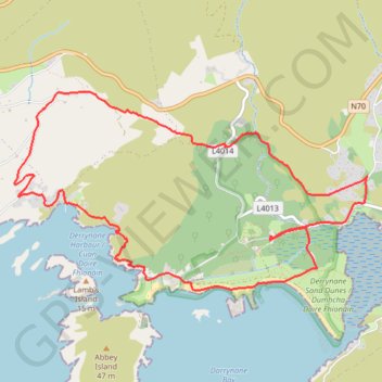
Name: Derrynane National Park GPS track, route, trail
Coordinates: 51.75966 -10.15704 51.77315 -10.11822
Other GPS tracks
Click on a GPS track to view route, its statistics and profile.
The-kerry-way-entire-trail-walking-route-map-and-guide-kerry-ireland
Irlande > Comté de Kerry > Killarney
Distance: 201.2 Km • Elevation gain: 5,003 m • Maximum elevation: 380 m
Waterville - Derrynane Beach - Caherdaniel
#Hike
Distance: 16.2 Km • Elevation gain: 439 m • Maximum elevation: 243 m
RT5-1 Rosslare - Kinsale
Distance: 2,860.3 Km • Elevation gain: 27,381 m • Maximum elevation: 420 m
Trace IRELAND
Distance: 1,506.7 Km • Elevation gain: 13,359 m • Maximum elevation: 524 m
RT5-1 Rosslare - Kinsale
Distance: 3,867.1 Km • Elevation gain: 36,115 m • Maximum elevation: 524 m
RT5-1 Rosslare - Kinsale
Distance: 1,353.5 Km • Elevation gain: 15,245 m • Maximum elevation: 420 m