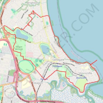
Deagan wetlands Sandgate
Brisbane Trail Run
- Distance: 16.2 Km
- Elevation gain: 64 m
- Maximum elevation: 22 m
- Elevation loss: 65 m
- Minimum elevation: 0 m
- Moving time: 1 h 24 m
- Moving speed: 11.4 Km/h
- Maximum speed: 18.0 Km/h
- Total time: 1 h 24 m
- Global speed: 11.4 Km/h
- Date: 17/04/2024
Interactive map
GPS track profile
About this GPS track
Name: Deagan wetlands Sandgate GPS track, route, trail
Start: Moreton Bay Cycleway, Shorncliffe, Brisbane City, Queensland, 4017, Australia (-27.32285 153.08408)
End: Moreton Bay Cycleway, Shorncliffe, Brisbane City, Queensland, 4017, Australia (-27.32275 153.08411)
Coordinates: -27.33377 153.04536 -27.30118 153.08816
Other GPS tracks
Click on a GPS track to view route, its statistics and profile.