Bromont
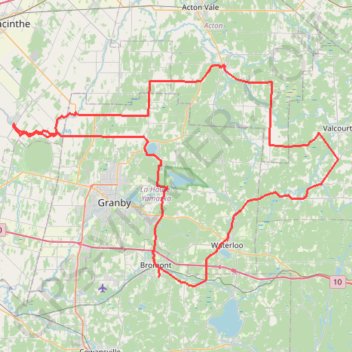
Interactive map
GPS track profile
About this GPS track
Name: Bromont GPS track, route, trail
Start: Rue Champlain, Bromont, Brome-Missisquoi, Estrie, Quebec, J2L 2K7, Canada (45.30246 -72.64051)
End: Rue Champlain, Bromont, Brome-Missisquoi, Estrie, Quebec, J2L 2K7, Canada (45.30249 -72.64052)
Coordinates: 45.29094 -72.90593 45.57371 -72.31323
Other GPS tracks
Click on a GPS track to view route, its statistics and profile.
Pierreville - Leclercville
Canada > Quebec > Urban agglomeration of Montreal > Montreal
#Bike #Pierreville #Leclercville #Atlantic
Distance: 120.8 Km • Elevation gain: 324 m • Maximum elevation: 36 m