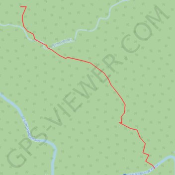
GrandePlaine
- Distance: 1.1 Km
- Elevation gain: 79 m
- Maximum elevation: 286 m
- Elevation loss: 97 m
- Minimum elevation: 194 m
Interactive map
GPS track profile
About this GPS track
Name: GrandePlaine GPS track, route, trail
Start: Pointe-Noire, Basse-Terre, Guadeloupe, 97116, France (16.20746 -61.75109)
End: Habitation La Retraite, Pointe-Noire, Basse-Terre, Guadeloupe, 97116, France (16.20150 -61.74594)
Coordinates: 16.20150 -61.75109 16.20746 -61.74594
Other GPS tracks
Click on a GPS track to view route, its statistics and profile.
Morne à Louis - Acomat - Morne Grande Ravine
France > Guadeloupe > Pointe-Noire
Randonnée pédestre. En boucle. #Randonnée #Boucle #Guadeloupe #Île
Distance: 12.3 Km • Elevation gain: 738 m • Maximum elevation: 651 m
Morne à Louis - Acomat - Morne Grande Ravine
France > Guadeloupe > Pointe-Noire
Distance: 11.9 Km • Elevation gain: 747 m • Maximum elevation: 651 m