Durrance Lake - Tod creek and inlet
Gowlland Tod Provincial Park. #Hike #Loop #GowllandTod
- Distance: 11.6 Km
- Elevation gain: 452 m
- Maximum elevation: 265 m
- Elevation loss: 452 m
- Minimum elevation: 5 m
Interactive map
GPS track profile
About this GPS track
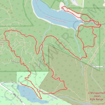
Name: Durrance Lake - Tod creek and inlet GPS track, route, trail
Coordinates: 48.54706 -123.48340 48.56171 -123.46010
Other GPS tracks
Click on a GPS track to view route, its statistics and profile.
Mount Work - Mount Stewart - Thetis Lake
Canada > British Columbia > Capital Regional District > Highlands
#Hike
Distance: 20.2 Km • Elevation gain: 697 m • Maximum elevation: 436 m